 by
by United States – If you are hoping to make Valentine’s Day dinner plans on an outdoor patio, you may want to reconsider. A developing storm system is expected to impact a large portion of the country late this week and through the weekend, potentially turning Valentine’s Day into a washout for millions of Americans.
While forecast details are still evolving, early indications suggest this system will bring more rain than snow across much of the nation, though winter weather remains possible in some regions.
Storm System Takes Shape Across the Southwest
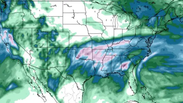
The weather system will begin forming across the Southwest, as an area of low pressure tracks eastward across the southern half of the United States. Meteorologists say the initial impacts will become noticeable on Friday, particularly from the Four Corners region to the Southern Plains.
During this phase, winter weather could affect the Southern Rockies, with a potential wintry mix extending as far south as parts of Arizona and New Mexico. At the same time, showers are expected from southern Arizona eastward into Arkansas, with the heaviest rainfall likely across Texas and Oklahoma. A few thunderstorms are also possible.
Friday Impacts: Rain Dominates, Snow Limited to Higher Elevations
Friday’s setup favors rain across lower elevations, especially in the southern states. Warmer-than-average temperatures across much of the region will limit snow to higher terrain, while valleys and urban areas see steady rainfall.
Some locations could experience brief heavy downpours, increasing the risk for localized flooding, especially in areas that receive repeated rounds of rain.
Saturday Brings Widespread Rain and Storms
As the storm system shifts eastward on Saturday, its reach will expand significantly. Rain is expected from the Deep South into portions of the Midwest and Ohio Valley, with thunderstorms becoming more likely along the Gulf Coast.
This timing could create challenges for major weekend events, including Mardi Gras celebrations in New Orleans, where more than one million people are expected to attend parades and festivities.
With warm air dominating much of the region, most precipitation on Saturday is expected to fall as rain. However, meteorologists caution that conditions could change overnight, especially if colder air moves in faster than expected.
Sunday May Be the Most Impactful Day
Sunday currently appears to be the most active and disruptive day of the system. Forecast models show precipitation spreading across nearly all areas east of the Mississippi River.
Heavy rain is possible from the Gulf Coast through the Southeast and into the Ohio Valley, while thunderstorms could develop across the Southeast. As colder air begins to wrap into the system, winter weather may return to the forecast for northern regions.
Snow and Ice Possible for the Northeast and Snow Belts
As colder air enters the system late Sunday, snow or a wintry mix could develop in parts of the Great Lakes Snow Belts and potentially into the Northeast.
Residents along the busy I-95 corridor, including cities from Washington, D.C., to Boston, should closely monitor the forecast. There is a chance of another round of snow or mixed precipitation, which could impact travel late in the weekend or early next week.
Why the Forecast Remains Uncertain
Meteorologists stress that forecast uncertainty remains high due to questions about the storm’s exact track.
If the low-pressure system tracks farther north, it will pull colder air into the region, increasing the likelihood of snow and ice for northern cities. A more southern track, however, would keep temperatures warmer and result in a predominantly rain-heavy event.
Forecasters expect confidence to improve as the system develops, and adjustments will likely be made over the next several days.