 by
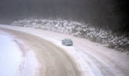
by Buffalo, New York — Winter is making its presence felt across western New York as snow and sleet spread across the region, creating slick travel conditions and setting up a volatile weather pattern just days before the New Year. Headlights cut through falling flakes early today as pavement darkens quickly and untreated roads begin to glaze with ice while temperatures hover near freezing.
According to the National Weather Service, a Winter Weather Advisory remains in effect for the Buffalo area through early Saturday. Forecasters expect two to five inches of snow and sleet, with light ice accumulation possible, especially during periods of mixed precipitation.
Hazardous Travel Develops Quickly
Road conditions are expected to deteriorate through the morning and afternoon hours. Slippery stretches are likely along I-90, Route 33, and major city arterials, where snow and sleet combine with marginal temperatures. Even small amounts of ice can significantly reduce traction, particularly on bridges, ramps, and elevated roadways.
The evening commute may be especially challenging as mixed precipitation continues and road crews work to keep up with changing conditions. Drivers are urged to slow down, increase following distance, and plan extra time if travel is necessary.
Snow Winds Down, Cold Holds Into Saturday
Snow and sleet taper late tonight, but cold air remains locked in place through Saturday morning. Clouds linger, and temperatures struggle to rise above the lower 30s, limiting melting and allowing slick conditions to persist.
Municipal crews will continue cleanup efforts, though some side streets and less-traveled roads may remain icy through the day. Shaded areas and parking lots are likely to refreeze overnight, keeping hazards elevated even after precipitation ends.
Sunday Brings Rain — and a New Set of Problems
Conditions shift noticeably on Sunday as milder air pushes into western New York. Snow transitions to rain by afternoon, with highs climbing into the upper 40s. While the warmer air helps melt accumulated snow, it also introduces standing water on roads and in low-lying areas.
The improvement may be short-lived. After sunset, temperatures begin to drop again, raising concerns for refreezing on untreated surfaces. Black ice may develop late Sunday night, particularly where melting snow and rainwater collect earlier in the day.
Windy, Unsettled Weather Returns Monday
By Monday, another strong system moves across the region. Forecasters warn of gusty winds that could exceed 45 mph, potentially blowing loose snow and reducing visibility at times. Rain is likely for much of the day, though precipitation could briefly mix with snow as colder air filters back in later.
Strong winds combined with wet and icy patches could make travel difficult, especially for high-profile vehicles on open highways. Power outages are not expected to be widespread but cannot be ruled out in the strongest gusts.
Read Also: Holiday Travelers Catch a Break as Gas Prices Fall Across the US
Active Winter Pattern Continues Into New Year’s Week
Looking ahead to New Year’s week 2026, winter weather remains active across western New York. Additional snow showers are possible Tuesday and Wednesday, with daytime highs falling back into the 20s.
Each cycle of melting and refreezing increases the risk of black ice during early mornings, particularly for commuters and holiday travelers. Even when snowfall amounts are light, repeated temperature swings can keep roads hazardous.
What to Keep in Mind
- Sunday: Rain develops, then refreeze risk after dark
- Monday: Windy with rain and possible snow mix
- Early week: Colder, with additional snow chances
Travelers are encouraged to stay weather-aware, monitor updated advisories, and adjust plans as conditions change. Winter driving kits and flexible schedules may prove especially helpful during this stretch.
As Buffalo heads toward the New Year, fluctuating temperatures — not just snowfall — will be the main challenge.
How are road conditions shaping up where you are in western New York? Share what you’re seeing and how you’re preparing in the comments below.