 by
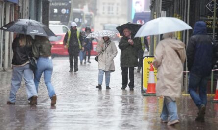
by California — A powerful train of Pacific storms is set to refocus its impact on California as the Christmas holiday approaches, bringing heavy rain, flooding risks, mudslides, and mountain snow across much of the state. Meteorologists say the pattern will turn increasingly active starting this weekend and persist through much of Christmas week.
After days of soaking rain and flooding in western Washington and Oregon, the storm track is now shifting south, placing California in the bullseye.
Pineapple Express targets Northern California this weekend
Forecasters say an incoming atmospheric river, classified as a pineapple express, will begin impacting Northern California late Saturday night through Monday.
A pineapple express is a concentrated plume of tropical moisture that stretches from near Hawaii to the U.S. West Coast, capable of producing intense rainfall over a short period of time.
This system follows another storm that will bring heavy rain to western Oregon through Friday, with some spillover rainfall into Northern California before the more powerful surge arrives over the weekend.
Heavy rain totals raise flooding concerns
The first storm through Friday night is expected to deliver:
- 4 to 8 inches of rain in northwestern California
- Around 0.50 inches in parts of the Sacramento Valley
- Up to 4 inches in portions of the Siskiyou Mountains and northern Sierra Nevada
The more concerning system arrives Saturday night through Monday, when rainfall rates could intensify rapidly.
Forecasters warn that several inches of rain could fall within just a few hours in west-facing slopes of the Coast Ranges, Siskiyous, and northern Sierra Nevada.
“Pockets of 6 to 12 inches are forecast, especially in the lower and intermediate west-facing slopes of the northern Sierra Nevada,” meteorologists said.
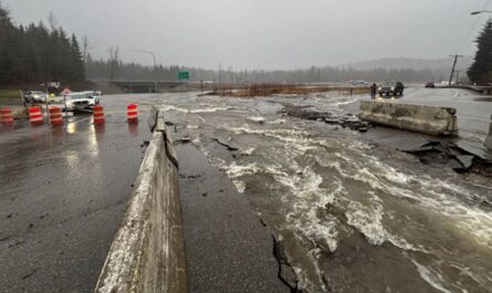
That volume of rain in 12 to 48 hours is enough to trigger rapid small-stream flooding, river rises, and mudslides, particularly in burn scar areas.
Read Also: Broward County Public Schools Approves 2026–27 and 2027–28 School Calendars
Urban flooding possible in Bay Area
In the San Francisco Bay Area, rainfall totals are projected to reach 2 to 4 inches during the heaviest phase of the storm.
Forecasters warn that:
- Roads may become slick with ponding water
- Urban flooding is likely where storm drains are blocked by leaves
- Low-lying neighborhoods could see localized flooding
Drivers are urged to allow extra travel time and avoid flooded roadways.
New storm system to spread rain statewide during Christmas week
The pineapple express is expected to weaken by Monday night, but the break will be brief.
A new Pacific storm is forecast to develop offshore by midweek, spreading rain across much of California from Tuesday through Thursday.
Because the ground will already be saturated from earlier storms, additional rainfall will significantly raise flood risks in Northern California, especially along west- and southwest-facing mountain slopes.
Southern California rain likely by midweek
Rain chances will increase across Southern California, potentially starting as early as Tuesday along the coast.
From Wednesday through Friday, forecasters expect:
- Drenching downpours in Los Angeles and San Diego metro areas
- Increased risk of urban flooding
- Disruptions to outdoor Christmas-related activities
At least some rain is likely on Christmas Day, with showers possibly reaching inland desert areas. Forecast models even suggest light rain could extend as far east as Las Vegas and Phoenix.
Flooding risk will be highest along the south- and west-facing slopes of the Transverse Mountains, where terrain enhances rainfall.
Sierra Nevada snow brings travel challenges
While rain dominates lower elevations, the Sierra Nevada will see fluctuating snow levels throughout the week.
Forecasters expect:
- Several feet of snow on higher ridges and peaks
- Periodic drops in snow levels down to Donner Pass along Interstate 80
This will benefit ski resorts and improve long-term water supply, but it may also create hazardous travel conditions, especially during peak holiday traffic.
Motorists are encouraged to monitor forecasts closely and carry chains when traveling through mountain passes.
Pacific Northwest to see brief relief
Meanwhile, Washington and Oregon will see less intense rain and snow compared to recent weeks. However, forecasters caution that the region is unlikely to remain completely dry, with occasional rain and mountain snow still possible through Christmas week.
What residents should do now
Weather officials urge Californians to prepare ahead of the holiday period:
- Clear leaves from gutters and storm drains
- Avoid driving through flooded roads
- Monitor weather alerts and travel advisories
- Use caution near burn scars and steep terrain
With multiple storms lined up, forecasters say this could be one of the most impactful wet periods of the season so far.
How might this stormy pattern affect your Christmas travel or plans? Share your thoughts in the comments.