 by
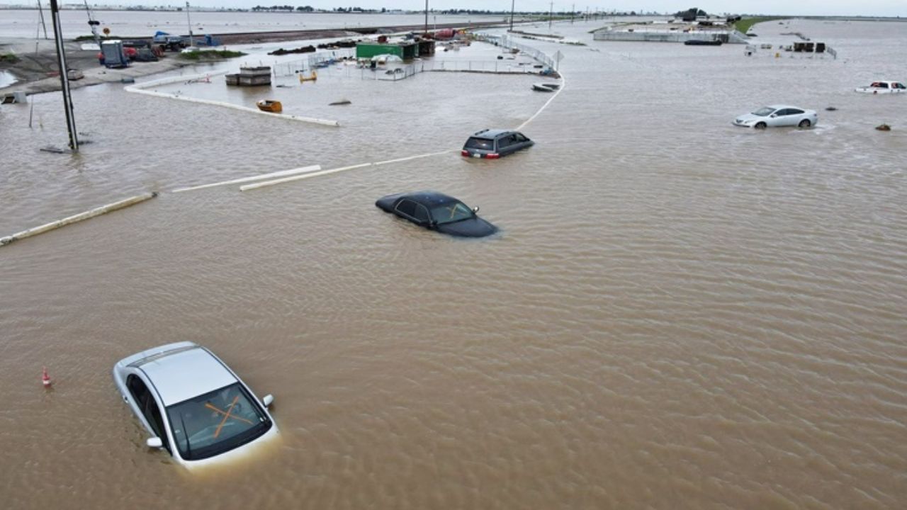
by Southern California, CA — Heavy rainstorms are pushing into fire-scarred regions across Los Angeles, San Diego and surrounding counties, placing more than 23 million residents under a flood watch through Saturday as emergency officials brace for possible mudslides, debris flows and dangerous travel conditions.
Storm Systems Bring Significant Rainfall to Burn Areas
Southern California is facing two back-to-back storm systems, with forecasters warning of 1 to 3 inches of rain on Friday across regions still recovering from January’s devastating wildfires. According to reporting from NBC News, the incoming moisture is already creating muddy and unstable ground due to a lack of vegetation in major burn scars.
Officials noted that up to 8 inches of total rainfall could fall in some areas by the end of the weekend, dramatically increasing the risk of flash floods and landslides.
Airport and Highway Conditions Rapidly Deteriorate
Early rainfall on Friday afternoon has already created hazardous conditions. At Los Angeles International Airport (LAX), about one inch of rain fell in a single hour, prompting concerns about delays and reduced visibility.
Along Highway 101, crews reported up to 6 inches of mud accumulation, with at least one vehicle stranded as responders worked to clear the roadway. Transportation officials warned that conditions may worsen as the second, more powerful wave of storms approaches.
Second Storm Expected to Intensify Through Saturday
Meteorologists say the next incoming system will be stronger, bringing winds and 2 to 8 additional inches of rain across Southern California. This heightened activity has prompted a widespread flood watch from 4 a.m. PST to 10 p.m. Saturday, as reported by the Los Angeles Times.
Read Also: Southern California Weather: Storm System Sparks Evacuation Warnings
Authorities are particularly focused on the most vulnerable regions, where steep terrain and wildfire damage combine to increase the threat of sudden debris flows.
Evacuation Warnings Issued in Multiple Counties
Ventura County issued an evacuation warning for Thursday through Sunday in the region impacted by the Mountain Fire, which burned through wide swaths of forest and foothill communities in January. Additional warnings are in effect for Camino Cielo, Matilija Canyon and North Fork, where residents have been urged to be ready to leave at a moment’s notice.
Emergency managers emphasized that heavy rainfall over burn scars can produce fast-moving mud flows even without prolonged rainfall.
Burn Areas Face Highest Risk of Mud and Debris Flows
Some of the burn zones with the greatest risk for dangerous slide activity include Eaton, Hurst, Kenneth, Palisades and Sunset, where the loss of vegetation has left hillsides unstable and prone to collapse.
“Mud flows and debris fields could develop quickly in areas damaged by January’s wildfires,” officials cautioned, noting that even moderate rainfall can trigger swift and unpredictable slides.
Forecasters warned that the combination of heavy rainfall, loose soil, and strong winds could cause extensive structural damage, road closures, and sudden flooding that may become life-threatening if residents are caught unprepared.
Storms May Signal the End of Fire Season
Despite the hazards posed by the storms, meteorologists say the widespread rainfall could mark the end of Southern California’s annual fire season, as saturated vegetation reduces the likelihood of rapid wildfire spread in the coming weeks.
Officials, however, continue to urge residents to monitor alerts, stay prepared for evacuation orders, and avoid traveling in areas where mudslides or flash floods are possible.
For more updates and in-depth discussions, join the conversation at mikeandjonpodcast.com.